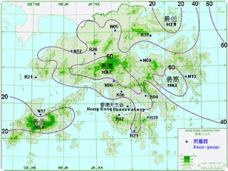
An isohyet is a type of contour map that measures the equal amount of rainfall in a given area during a certain time period. Due to the fact that the amount of rainfall can vary from year to year, theses maps can help analyze climate variability. The picture above is an isohyet from Asia. Areas that received the same amount of rainfall are connected by contour lines. According to the map, most of the area received 40 (can’t tell units) of rain.
http://www.einfopedia.com/tag/what-is-isohyet
No comments:
Post a Comment